


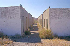
A row of quarters for single miner's
stands out in the desert.
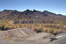
A ghost town that really is
'out in the middle of nowhere'

Of all the ghost towns near Bouse, Swansea is the best preserved; with ruins of a large brick smelter, mine, and more than a dozen buildings. The Clara Consolidated Gold and Copper Mining Company built a copper smelter in the early 1900s to process ore locally instead of shipping it to such faraway places as Swansea, Wales. Clara Consolidated closed the smelter in 1912, but other companies continued mining until 1924.
Swansea's post office was established March 25, 1909 and was discontinued June 28, 1924. Swansea was the headquarters for the Clara Consolidated Gold and Copper Mining Company. A railroad connected Swansea to nearby Bouse in 1908 and the camp’s population grew to a total of 750. Swansea had an electric light company, an auto dealer, a lumber company, even a barber and an insurance agent. The town was active until 1924 but the original mining company went bankrupt in 1912. There are two cemeteries at the site, and ruins of the smelter are extensive. Swansea was named after Swansea, Wales, where refined ore from the site was shipped. The ore was shipped via railroad to the Colorado River, where it was transferred to river freighters and then again transferred to ships on the Gulf of California for shipment to Swansea, Wales, via Cape Horn.
Swansea existed for only 15 years before the town disappeared into the desert. The town is in middle of nowhere and it is mystery in itself. The town did not have gold rush-era buildings and stores like Jerome, Oatman or Bisbee. The area was first investigated in 1886 by three men who were disappointed when the ore showed only copper and silver. When copper’s value increased 10 years later, one of them came back with a new partner and a little mining started.
The short existence of Swansea ended after WWI when copper prices dropped. By 1937 Swansea was already a ghost town.
HOW TO GET THERE
To reach Swansea from Bouse on Arizona Highway 72, 27 miles southeast of Parker,
- Take Main Street northwest (left off the highway) over the railroad tracks.
- Turn left again at the stop sign onto Raydar Road, which changes into dirt at the Bouse Y trailhead – look for the BLM information sign on the left.
- Take the left fork of the road – Swansea Road – which later crosses the Central Arizona Project canal.
- Thirteen miles from Bouse is the destroyed town Midway, which was the water stop on the short railroad line connecting Bouse and Swansea.
- Bear left on the fork at Midway, crossing under power lines after 0.4 mile, and go northwest 5.7 miles to Four Corners road junction,
- Then turn right 7.2 miles to Swansea.
Obtain local advice and good maps such as the Swansea 15-minute topo map. There is a walking tour map available that is generally available at the Bouse Museum during winter

44362 E. Main Street
(P.O. Box 817)
Bouse Arizona
PH: (928) 851-2509

CLICK HERE to meet the Board
or Download Minutes & Agendas

The Chamber | Historic Bouse | Become A Member Membership Directory | Events | Newsletter
Founders Day | Christmas Event | Dedication | Swap Meets | Bouse Museum
'Live' | 'Play' | 'History' | 'Community'
Assay Office & Museum | Mining Shack | Poston | Swansea | Memorial Park | 'Gizmo' | 'Sandy'